

Our present coordinate system for mapping the earth was devised by Claudius Ptolemy around 150 AD. To locate places, Ptolemy traced out a grid system of latitude and longitude over the globe.
Latitude is based upon the earth's rotation. As the earth spins, its axis defines a North Pole and a South Pole. (The North Pole, as mentioned in Voyagers, points directly at Polaris, the North Star.) Midway between these poles, Ptolemy marked a circle called the equator. A set of parallel circles was drawn above and below the equator. These circles of latitude gauge how far north or south a place is on the globe. The latitude of the equator is 0o. The North Pole is at latitude 90oN, while the Sole Pole lies at 90oS.
Anyone can quickly estimate latitude from the Polaris. Just measure how high Polaris stands above your horizon. That angle (called altitude) equals your latitude. If you travel south, Polaris follows, dropping in step with your lower latitude. At the equator, Polaris touches the horizon. Below the equator, it is not visible.
Perpendicular to the circles of latitude, Ptolemy traced out another set of circles that intersected at both poles. These circles of longitude measure how far east or west at place is. By international agreement, longitude ranges from 0o at the Greenwich meridian to 180o at the International Dateline.
Sailors need precision clocks to figure out their longitude. This should not be surprising, since the earth's rotation was our original basis for time. Each circle of longitude can be compared to the numbers on the face of a clock. As the earth spins, the noonday sun stands over a different circle of longitude. The first person to construct a watch that could withstand the vigors of the open sea was an English carpenter named John Harrison.
Activities:
1.) A turntable and stopwatch can help students understand how longitude is determined by aid of a clock. Any turntable with a slow rpm setting (15 rpm or less) can be used. A popular toy like the 25 Gulpin' Guppies fishing game (Figure 5) makes an ideal, yet inexpensive turntable.
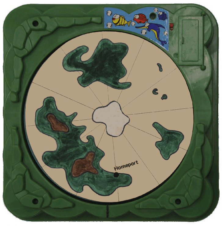
Draw a polar map on cardboard to fit the turntable. The map can either be of earth or some fantasy world. Identify one place on the map as homeport.
With the map spinning on the turntable, have the students time the period for one rotation. This is an excellent chance to teach averaging techniques by timing multiple rotations and dividing.
Stop the turntable and adjust the map so that homeport is in front. Hide the map with a cardboard cover. Simultaneously start a stopwatch and the turntable. After a few seconds, stop the turntable and watch. With this data, students should be able to estimate what part of the map is facing front. For example, assume the turntable rotates once every 8 seconds. If the map spins for 6 seconds, it would have rotated 6/8 or 3/4 of a turn. This is conceptually the principal behind the use of a chronometer to measure longitude.
2.) By noting the time zones for different locations on earth, one can estimate the distance between them. At the equator, 15o of longitude equal about 1,000 miles. Since time zones are 15o wide, they are also about 1,000 miles across.
Example: Since Honolulu is 2 hours behind Los Angeles time, these two places are 2 time zones away or approximately 2,000 miles.
Estimate how far away Miami is, if it is 5 hours ahead of Honolulu.
When it is 6 pm in New York, it is only 3 pm in San Francisco. Estimate how far apart these two cities are.
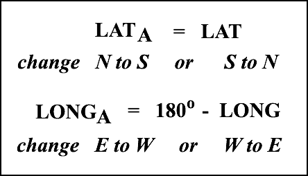
3.) According to the China Syndrome, if a nuclear power plant experienced a meltdown, its core would sink through the earth and supposedly end up on the opposite side of our planet. Every location on earth has a counterpart that is directly opposite, called its antipodal point. The North Pole's antipodal point is the South Pole.
Use the following conversion formulas to find the coordinates of the antipodal point (LATA, LONGA) for any location on earth given its coordinates (LAT, LONG).
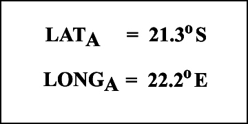
Find the coordinates of the antipodal point for Honolulu (LAT = 21.3oN and LONG = 157.8oW).
Solution
Identify Honolulu's antipodal point on a globe.
Solution
Have the class calculate the coordinates for the antipodal points of cities like Beijing, New York, London, Sydney, Venice and Tokyo. Locate these antipodal points on a globe.
4.) Locate the following places that were mentioned in Voyagers on a globe or map.
- Venice (Marco Polo's birthplace)
- Spain (kingdom of King Ferdinand II and Queen Isabella I)
- Canary Islands (Columbus began his voyage across the uncharted Atlantic from this Spanish possession. The Canary Islands were named after the wild dogs that lived there. Canis in Latin means dog, from which we get our word canine. The canaries that lived on these islands were named after the island.)
- Caribbean Sea (the surrounding sea for Columbus' landfall)
- Jamaica (where Columbus witnessed a lunar eclipse while
marooned in 1504) - Polynesian Triangle (its corners marked by Hawaii, Easter Island and New Zealand)
- Japan (called Cipangu in 1492)
- China (called Cathay in 1492)
- Alexandria (in Egypt, where Eratosthenes measured the circumference of the earth)
- Antarctic Ocean (where Captain Cook witnessed the auroras of the South)
Further Reading:
Jack McClintock and David Helgren, Everything is Somewhere, 1986; Exploring Navigation, A Publication of the Exploratorium, pp. 10-13, Spring 1991.